The maps in this section are approximately 400K in size and will therefore take some time to load.
Maps will open in a fresh window whilst text will appear on the right.
Key Plan - shows Areas
Map
- Area A - Zimba to Tara
Report and Recommendations Area A
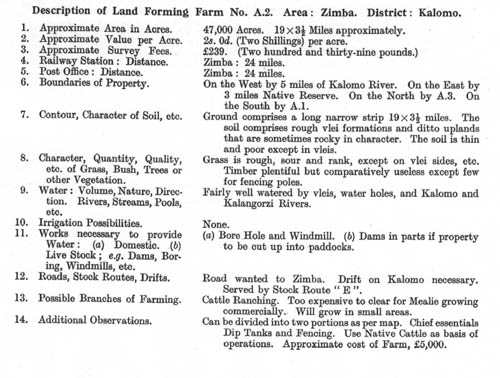
Farm Reports
Map
- Area B - Tara to Magoye
Report and Recommendations Area B
pg48 pg49 pg50 pg51 pg52 pg53 pg54
Farm Reports
Map
- Area C - Magoye to Lusaka
Report and Recommendations Area C
pg102 pg103 pg104 pg105 pg106 pg107
Farm Reports
C220-221-222 C223-224 C225-226-227 C228
Map
- Area D - Lusaka to Broken Hill and Kalulu
Report and Recommendations Area D
Farm Reports